Most destructive eruption in Hawaiʻi in 200 years began 5 years ago on Kīlauea


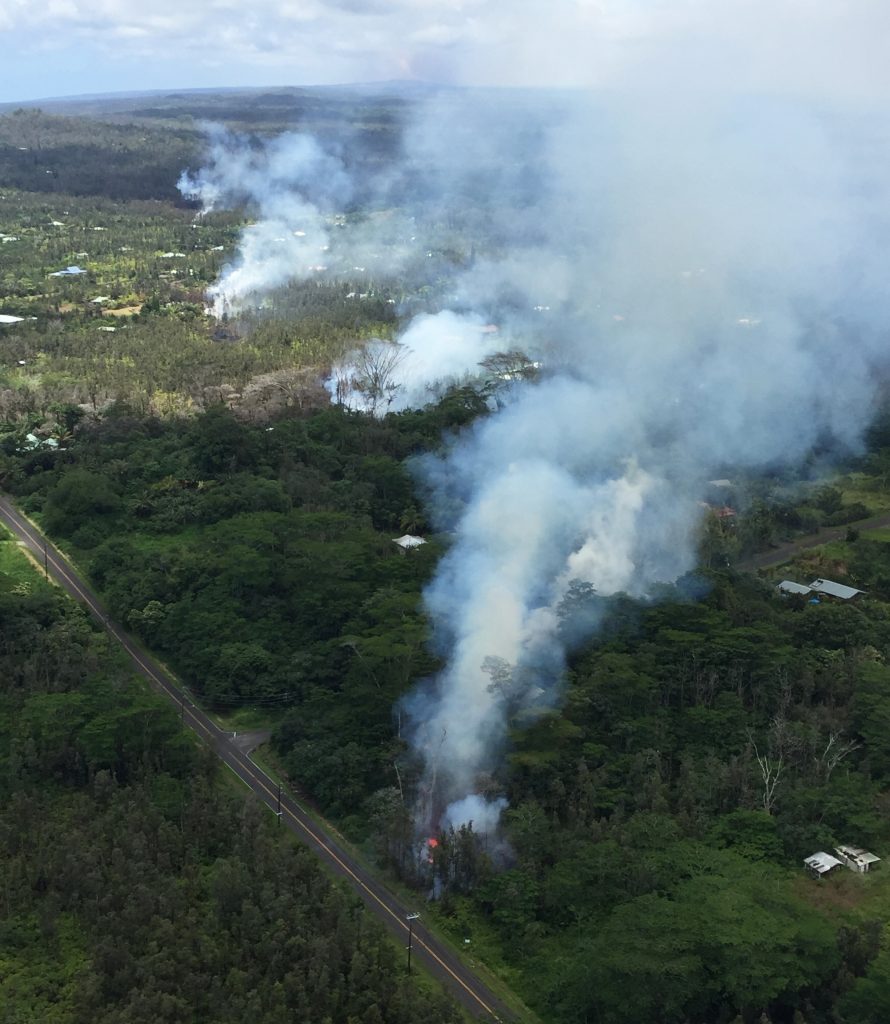
The sun was shining through partly cloudy skies the afternoon of May 3, 2018, when Ikaika Marzo went live on Facebook at about 4 p.m. from Mohala Street in Puna’s Leilani Estates.
Marzo, a business owner and community leader who would later run for Hawai‘i County mayor in 2020, had been tracking ground openings and cracks on lower Puna roadways. They had been forming after the Pu‘u‘ō‘ō vent on Kīlauea volcano’s middle East Rift Zone collapsed just a few days earlier on April 30.
As he was patrolling the area that fateful afternoon — looking for more signs that the volcano could be getting ready to erupt elsewhere — he ended up at ground zero.
“Oh my god! It’s happening! It’s happening!” Marzo exclaims to the people watching him on Facebook as he watches a plume of white smoke down the street mark the spot where lava starts spewing out of the first fissure.
Today, its the 5-year anniversary of that official start to the unprecedented 2018 eruption in Kīlauea’s lower East Rift Zone

On that day, people and scientists didn’t know that this would be the volcano’s largest lower East Rift Zone eruption and accompanying summit collapse in at least 200 years. It also would prove to be the most destructive eruption in Hawai‘i in two centuries.
Marzo has been widely recognized for his efforts monitoring the eruption, sharing information and organizing donations for the affected communities. He spent much of the video warning people the eruption was underway and urging them to evacuate, all while ash began falling and smoke and volcanic gases bellowed from the fissure just down the street.
“I just letting everybody know right now, if you guys watching my feed, we have an eruption. We have an eruption. Just letting everybody know, we having one eruption right now,” Marzo says in the video. “Eruption in Leilani, no joke. Lava is coming out right now.”
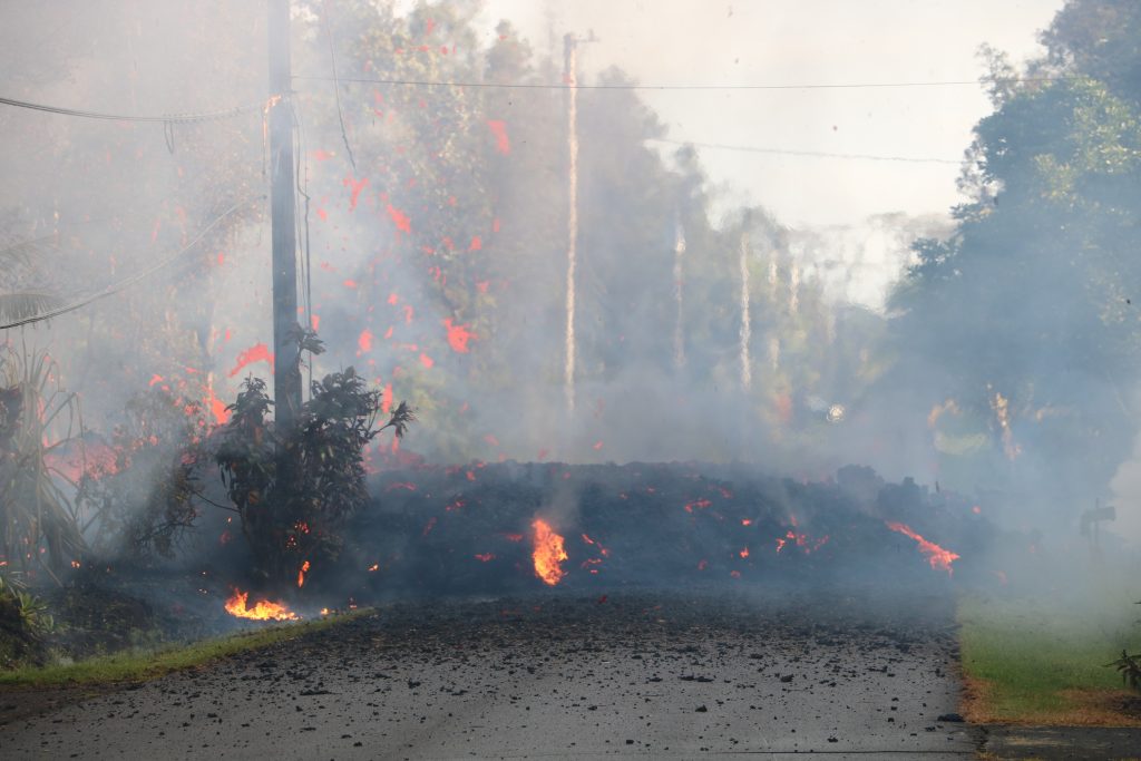
Lava crossed Mohala Street while he was still live on Facebook. At one point, he put his shirt over his nose and mouth to protect himself from the fissure’s emissions. Others can be heard coughing in the background. County workers can be seen blocking off the road with cones as helicopters fly overhead.
“Eruption right now,” he tells one man parked on the side of the street who replied in disbelief. “Yeah. So get your stuff out of here.”
His main concern was the safety of the people in the area.
“Evacuate right now. The lava is pumping out right now,” Marzo tells another couple who lived nearby and were also in their vehicle.

“Are you serious?” the woman asked in shock.
“I’m serious,” he says. “There’s an eruption right here.”
The video lasts a little more than nine minutes, but the eruption would not end for four months, spawning more than 20 lava-spewing fissures and causing portions of Kīlauea’s summit to collapse.
It was a completely different beast than Kīlauea eruptions during the past few years, which have all been confined to Halema‘uma‘u crater at the volcano’s summit within Hawai‘i Volcanoes National Park.
“The 2018 eruption of Kīlauea volcano had devastating effects on the lower Puna district, destroying hundreds of homes, burying subdivisions and permanently affecting the lives of thousands of residents,” said the March 31, 2022, installment of “Volcano Watch” by the Hawaiian Volcano Observatory.
It also marked the end of a 10-year eruption at the volcano’s summit, which started in 2008, and another at the Pu‘u‘ō‘ō vent, which lasted 35 years and was the longest and most voluminous known outpouring of lava from Kīlauea’s East Rift Zone in more than 500 years.
The collapse of Pu‘u‘ō‘ō created a crater, forcing magma to move below ground toward and into the lower East Rift Zone. It also prompted an increase in seismic activity and deformation down rift of the vent, with tremors as far east as Highway 130. The collapse followed a large overflow of lava onto the floor of Halema‘uma‘u crater.
Deflationary tilt at Kīlauea’s summit began the next day and the lava lake began to drop May 2 as magma drained from the summit reservoir and was redirected to the lower East Rift Zone. The first small ground cracks opened in and adjacent to Leilani Estates, but no steam or high temperatures were recorded.
A magnitude-5 earthquake at 10:30 a.m. on May 3 rocked the Big Island and caused additional collapse at Pu‘u‘ō‘ō, producing a short-lived plume of reddish ash. The eruption officially began sometime about 5 p.m.
Hawai‘i County Civil Defense immediately issued a mandatory evacuation order for residents of Leilani and nearby Lanipuna Gardens.

By the afternoon of May 4, 2018, six fissures had opened in lower Puna and seismicity was increasing at the summit. A monster magnitude-6.9 earthquake, one of three tremors of magnitude-5 or greater that day, rocked the island at 12:31 p.m., producing a robust ash plume at Pu‘u‘ō‘ō.
The quake, which was felt as far away as O‘ahu, was the largest in Hawai‘i since 1975 and caused some damage, including several landslides on the Hāmākua Coast in East Hawai‘i.
The number of fissures increased to nine by May 5, including the opening of fissure 8, which would later become the most active fissure and focus of lava activity for much of the eruption. The fissure, renamed Ahuʻailāʻau in 2021 by the Hawai‘i Board on Geographic Names, opened at the edge of Luana Street in Leilani and built a spatter cone, with fountaining and occasional bursts to more than 300 feet.
A 10th fissure had opened by May 6 and the lava lake at Kīlauea’s summit had dropped significantly, falling more than 700 feet below the crater rim and completely out of view. Rockfalls, which generated small ashy plumes, had become common at the summit.
“The Leilani Estates subdivision on the east side of the Big Island (Puna) is literally being ripped apart,” wrote Mick Kalber in a May 6, 2018, Facebook group post. “This morning’s fissure eruption was by far the largest we’ve seen so far … starting just above Luana [Street], she crossed Leilani [Avenue], and poured lava into a group of homes to the north.
“Generally, these fissure outbreaks have begun violently, and quit[e] quickly … but this one appears to be an exception. The fountains were carrying lava over two hundred feet into the air in a spectacular display! In the 40 minutes we were there, we watched her destroy two homes, and there were any number of others in close proximity.”
By 3:15 p.m. on May 7, 2018, all of the then 12 fissures that had opened since the beginning of the eruption were inactive, but heavy steaming and elevated gas emissions continued. A ground crack also extended across Highway 130. On May 8, the number of fissures had increased to 14, with two new fissures erupting near previously active vents in Leilani.
That was all in just the first five or so days. By the end of the four-month eruption, 24 fissures had opened throughout lower Puna and an area of more than 8,700 acres was covered by lava, including 875 acres of new land created near the eastern end of the Big Island.
Lava wiped out some subdivisions completely and others partially, destroying more than 700 structures and 30 miles of roadway, and displacing more than 2,000 people on its march to the ocean.
At one point, lava flowing in the channel from Ahuʻailāʻau was moving at up to 17 miles an hour. Lava also landlocked the boat ramp at Pohoiki Bay, and other uninundated properties in the lower East Rift Zone became inaccessible because lava flows blocked access.

“To get a sense of how voluminous the 2018 lava is, imagine a giant cube of lava sitting on the ground that is 0.7 miles tall — or about three times as tall as the Empire State Building,” the March 31, 2022, “Volcano Watch” said. “For Island of Hawai‘i residents, this is about 27 times as tall as Bayshore Towers in Hilo.”
Much of Hawai‘i and places as far away as Guam also experienced vog, or volcanic fog. Nearly 200,000 metric tons of sulfur dioxide were emitted each day during the 2018 eruption, the largest emission rates ever measured on Kīlauea. A total of 10 megatonnes of sulfur dioxide were pumped into the air between May and early August 2018.
At the summit, Hawai‘i Volcanoes National Park infrastructure was damaged by the more than 60,000 earthquakes that rocked the area from May through August. The Hawaiian Volcano Observatory was forced to move from the Jaggar Museum because of the summit’s instability.
Every 28 hours on average through July 2018, the ground within Kīlauea’s summit caldera sank. These collapses were followed by large plumes of ash. An explosive eruption at the summit May 17, 2018, sent up an ash cloud that extended 30,000 feet into the sky. The collapse of the summit and explosive events within even flung dense ballistic blocks of up to about 2-inches into the Overlook parking lot at the national park.
In total, the caldera deepened by more than 1,600 feet and its diameter more than doubled because of collapse events. The last summit collapse event was Aug. 2, 2018.
By Aug. 4, lava rates and sulfur dioxide emissions at Ahuʻailāʻau were greatly reduced. Lava was only intermittently visible inside the cone during the next month. Ocean lava entries ceased by Aug. 21, and active lava was last visible within Ahuʻailāʻau on Sept. 5.
A Sept. 25, 2018, post on the Kīlauea Eruption 2018 :: Perceptions and Perspectives Facebook page summed it up best: “To see land that that is newly created, landscapes utterly rearranged by the hands of the earth itself in rapid human time rather than slow geologic time startles the imagination.”
Editor’s Note: Throughout the next four months, Big Island Now will share stories about the people and places affected by the 2018 Kīlauea eruption as part of an occasional series. We also will take a look at recovery efforts, including what has been done, what hasn’t and how much is still needed.
Do you have a story to tell from the 2018 eruption? Let us know via email at newsdesk@bigislandnow.com.


